Townscape assessment
This is an amended and updated version of the description of Datchet included in the Townscape Assessment Final Report Volume 2: Windsor Group, RBWM, prepared by Land Use Consultants, June 2010, and included as part of the submission version of the Royal Borough of Windsor & Maidenhead Council's Local Plan.
Description and evaluation of Datchet
Physical Influences and Landscape Setting
Datchet lies within the Thames Valley floodplain, on a bedrock geology of London Clay and Reading Beds which is overlain with deposits of alluvial sands and river gravels. The settlement is within NCA 115 Thames Valley, and mostly within the Environment Agency’s flood zones.
Datchet evolved from a historic crossing point on the River Thames, which provides a unique riverside setting to the town. Waterlogged pastoral fields beside the River Thames dominate the landscape setting of Datchet; this landscape forms part of the Settled Farmed Floodplain landscape type. Beyond to the west is the historic landscape of Windsor Home Park whose historic tree-lined avenues form a distinctive element of the landscape setting; this landscape forms part of the Farmed Parkland landscape type and includes parkland areas associated with the medieval Royal Hunting Forest of Windsor. Windsor castle sits on a prominent chalk outcrop west of Datchet. Bordering the east of Datchet are large reservoirs which form part of the Settled Development Floodplain landscape type.
The name ’Datchet’ is thought to be of Celtic origin although there is no obvious etymological explanation. In 1982, the historian K Rutherford Davis, writing about Celtic place names, linked Datchet (in Latin, Daceta) with Decize (Decetia). This fortified town, at an island crossing point in the River Loire, was described by Julius Caesar in his Gallic Wars as occupied by the Decetia tribe. The origins of Datchet appear ancient with evidence of Neolithic, Bronze, Iron Age and early Romano-British activity associated with the river crossing point.)
Datchet was subject to a Saxon land charter in the 10th century, with the village identified as forming part of the Royal Forest at Windsor by 1086. The importance of the settlement in relation to the Royal Estate was indicated by the provision of a Royal Barge and use of the river crossing at Datchet as part of the processional route to Windsor Castle in the 13th Century. The river was crossed by ferry at this point until replaced by a sequence of successive bridges from 1707-1852.
Much of the village was built in the level Thames Floodplain, but not around the present iconic village greens as it now appears. Until it was culverted c1850, a stream ran from the north alongside the modern Slough Road, widening in the middle of the village and out towards the east where it joined the Thames near Wraysbury. From the top of High Street there was a bridge across the stream, not to be confused with the series of Thames bridges. The culverted channel now emerges by Green Lane to run as a brook across Datchet Recreation Ground and into other channelled or culverted watercourses. St Mary’s Church was built on the one significant high point of land in the area, probably the site of a pre-Christian fortification. It was close to the northern bank of the stream, and the medieval settlement developed closely around it, taking advantage of the higher ground. Original land plots and buildings here can be traced back to the 14th century, as owned by Datchet Parish, St George’s College and Eton College.
On the lower south side of the stream, development took place in the 16th and 17th centuries. The Manor Houses and Manor Cottages retain complete timber frames, although the cottages were refronted in redbrick Georgian fashion, and the Manor Houses in Mock-Jacobean applied timber in about 1870. The Manor Hotel may have a timber-framed core of the 16th or 17th century, with all its present frontages added in the 1880s. This whole southern range of buildings was owned directly by Datchet Manor until sold in the 1890s. The stream was recorded as being a danger to children and a flooding nuisance until the culverting in 1850. Only then was the dry land created which became the present Greens. Almost all the buildings now edging the Green are older, at least in origin, than the village green itself. They were not built around it. High Street, linking the village centre and the riverside, is a medieval development with its houses recorded in Manorial Rolls of the 16th century, although mostly re-fronted later in fashionable redbrick Georgian style
Horton Road was the earliest main road into and out of the village as part of the route between Windsor Castle: by ferry or bridge over the Thames, and on to London via Colnbrook and the Bath Road. Many small plots (later amalgamated into the prestigious Lawn and Leigh estates), were developed along the north side of Horton Road by the 16th century. They bordered the edge of the funnel-shaped Datchet Common which widened towards the eastern parish border with Horton. (No common land remains as it was all redistributed by the Enclosure Act.) London Road was a narrow lane leading to Ditton Park and Riding Court until it was turnpiked in the 1760s and became a major route. There was no development beyond its foot near the church until the 20th century. Slough Road was known as ‘watery lane’, with a stream running alongside it, and there was no development at all beyond the west end of the village itself until the late 19th century. No road (except field paths), led to Windsor until after the route changes associated with the railway c1850. The old direct route to the Castle was by ferry or bridge over the Thames and through what was then public ground below the Castle on the Berkshire side. The only old road route from Datchet to Windsor town was along Slough or Eton lane, through Eton and over Windsor Bridge.
Around 1850 all the routes to and through Datchet changed more radically than ever before or since. Once the village centre stream had been culverted and the bridge over it was removed, the village centre became dry land. At about the same time, the L&SW Railway Company was extending its route from Staines through Datchet to Windsor Riverside, also becoming involved in the Windsor Improvement Plan. By this scheme, Datchet’s Thames Bridge was removed and there was no further access to the Berkshire bank, which then became private. Victoria Bridge was built further upstream, carrying a newly-built road into Windsor, and Albert Bridge downstream, taking another new road past Southlea and on to Old Windsor.
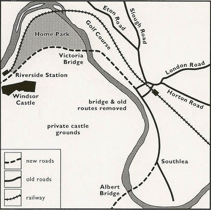
Above: Map of route changes around Datchet c1850 due to the arrival of the LSWR railway
The changes were as follows:
The presence of Datchet’s mainline station led to great popularity of the village as a fashionable resort for river sports, as well as London commuters increasing demand for houses. By the 1870s an agricultural depression led to the first sales of land in and around the village core for more profitable housing development, resulting in the construction of suburban streets in the late Victorian and Edwardian era (1890-1910) e.g. at Montagu Road and Buccleuch Road, where slate roofs, russet and gault brick, render and timbered gables are all evident.
As Datchet’s late-19th-century housing boom brought prosperity to local building-trade workers, they began to buy land to build new homes for themselves and for renting to labourers. Examples of these exist as good-looking brick terraces and semi-detached houses on both sides of Horton Road at its east end. (Victoria and Albert Villas, with Jubilee Cottage in between, all suggest the date of Queen Victoria’s 1887 Golden Jubilee.)
By the early 1900s, there was a severe shortage of housing for the working classes and the poor, which was traditionally clustered around the old Datchet Common area of Horton Road. With the help of high-status residents, the Datchet Co-Partnership Housing and Allotment Society was founded, influenced by the Garden City movement. Before WWI, around 30 vaguely Arts & Crafts ‘cottages’ had been built on Ditton Road, north and south of the c1900 cemetery and its chapel (now Grade II listed). Each dwelling had its own pig-sty and allotment to encourage self-sufficiency and alleviate severe overcrowding in the old cottages of this area which had deteriorated to slum conditions. (In the 1970s, the land occupied by these allotments was taken up by the Queen Mother Reservoir, but these houses remain pleasant and sought-after.)
There was limited growth in the interwar period. Eton Rural District Council built Lodge Field Cottages, 36 social housing cottages, opposite the allotment cottages on Ditton Road in the 1920s. A small estate of detached houses was built in the former gardens of Leigh Park. Similarly a section of The Lawns estate was sold for residential housing. Castle Avenue, a development of bungalows – unusual for Datchet – was also built during this period. Cranebridge Estates of Twickenham bought a very large area of agricultural land from the Barker family in 1930 which was bounded by London and Ditton Roads and had previously belonged to John Kinross of Riding Court Farm. Apart from two new avenues, Montrose and Fairfield Avenues, the estate extended along the upper part of London Road, then named Crane Way, where a row of substantial semi-detached houses was built. Development ceased at the outbreak of war in 1939, and afterwards the roads which had been opened up but left incomplete were used to build council housing, extending into Montrose Close and Montrose Way.
In the post-war period to the 1960s, more growth occurred within the grounds of larger villas, surrounded by suburban streets and cul-de-sacs. In 1950 the huge arable Marshfield on the south side of Horton Road was purchased as a playing field or Recreation Ground, although it had previously been earmarked for a major housing development.
The 1970 Bucks Plan for Datchet was drawn up in the few years before South Bucks Council was replaced by Unitary Authorities in this this area. It was a comprehensive audit of land management, highways, public amenities and housing. During the next few decades, almost all its recommendations were carried out. Five sites of varying size were earmarked for 1500 new homes, some recommended to be built at the close density of recent local authority provision nearby, while at others much more space was to be accorded to each dwelling. The social housing sites were to the north and south of Horton Road east: at New and Penn Roads and the Holmlea estate, now mostly managed by Housing Associations. (Datchet’s old workhouse had been at the far end of Holmlea Road.) The less dense housing and more open sites, built by developers, included Lombardy Park at the far end of Montagu Road, and Beaulieu Close. The site of Ruscombe Gardens, where Eton Road meets Slough Road, was to be left undeveloped in the hope that it would be used for one arm of the by-pass being proposed in the Plan. When that project eventually failed to materialise, the present small and varied estate was built in the 1980s in very pleasant wooded surroundings. Nearby, several large Victorian villas in Eton Road were replaced by quite formal closes of modern houses (Eton Close, Gables Close).
Late 20th-century development has taken place at Agars Place, off Castle Avenue. And, early 21st-century development at Ellesmere Close, off Eton Road, and more recently at Mead Close, Slough Road, with two block of three-storey flats fronting the road with a gated development of ‘Regency’-style detached houses to the rear, a style not seen elsewhere in Datchet. There are no other gated developments in the village.
The River Thames, the M4 motorway (which opened in 1965), and the reservoir (1976) all act as a natural barriers to growth and sprawl.
There is only a short stretch of public Thames riverside access; it belongs to the Parish Council (with a small section leased from RBWM) and is well kept, with grass and mature trees framing the wide river view. An important component of the settlement setting is the visual relationship to the Royal Estate, with views across to the Home Park from within the Conservation Area, with vestiges of the tree-lined processional route between the castle and the village still evident. The medieval ferry service operated from this site, and a Parish Council plaque marks the site of the 18th- and 19th-century bridges, built directly in line with the High Street. Almost all the rest of the riverside is inaccessible due to private garden curtilages and boat houses associated with large Georgian, Victorian and Edwardian built from the 18th to early 20th centuries, making this area of open public space to the riverside even more significant. Crown Estate had long owned the land bordering the Thames from Datchet northwards to Victoria Bridge, which is now leased to Datchet Golf Club. From the 1880s Crown Estate set out to purchase all riverside property southwards from Datchet to Albert Bridge, so that control could be maintained, and the Castle’s privacy protected along both banks. Several prestigious large riverside houses with grounds had been built at Southlea by the 16th century, all now rebuilt on old sites. Southlea Farm still occupies the whole deep bend of the Thames where an important multi-period archaeological settlement has been investigated.
Urban Structure
Historic gateways
There are four historic gateways to Datchet. The first is the western approach to the village green from Eton and Slough Roads; the second is the eastern approach to the green along Horton Road; the third is from north-east along London Road, where a wide open view of the village centre only appears when the church is reached, and the fourth is the approach to the village core from the High Street leading from the Thames to the south-west.
Nodes
The village green, which forms the central focus for the village core, represents the principal node within the settlement. The other is the Recreation Ground (including Village Hall, youth centre and play areas).
Landmarks
Datchet’s landmarks include the church spire (recently restored) and the mock-timbered Manor Houses, running along the south side of the Green, with Manor Hotel occupying the corner of High Street.
Key views
There are important views to the riverside and Windsor Home Park from the foot of the High Street, the old site of the ferry and bridges at the Thames crossing point.
Values
During the stakeholder workshop on 23rd September 2008 the following values were identified by the local community:
1. The Recreation Ground.
2. Sense of community to the village centre.
3. Mixed community (age).
4. Ease of access to transport infrastructure – motorway/railway.
Datchet’s Neighbourhood Plan team did a more widespread survey in 2017. The results indicated that the local community want to keep Datchet’s character as a village and ensure that growth within the Parish is sustainable, meeting the needs of residents and businesses without compromising the heritage, friendly atmosphere and community spirit of the whole village. (See www.datchetneighbourhoodplan.org/a-summary.html)
Based on residents’ values, the survey identified the following guidelines for development in the village:
Guidance/Opportunities for Datchet
Datchet is a compact riverside settlement, focused on the village green and clearly defined historic village core, with landmark churches and historic buildings, and with strong links to its riparian landscape setting. The Townscape Assessment [prepared by Land Use Consultants, June 2010 and included as part of the Borough Local Plan Submission Version] recommended that the following strategic principles are taken into account in the development design process and in public realm improvement projects:
1. The maintenance and enhancement of the physical and visual links to the riverside setting to the western edge of Datchet, in particular the conservation of key views to the Thames and Windsor Great Park beyond, which are available from Datchet High Street.
2. The integration of the western settlement edge with the riverside setting, using planting which reflects the riverside character.
3. The integration of the south-eastern and southern settlement edges around Datchet Common with the wider valley floodplain landscape setting.
4. The retention of the historic village core as the main focus for the settlement.
5. The retention of the village green as a key node and point of focus within the village.
6. The conservation of the western approach to the village green from Eton Road and Slough Road; the eastern approach to the green along Horton Road; the approach from the north-east along London Road; and the approach to the village core from the river to the south-west as key gateways into the historic core.
7. The conservation of the church spire and the historic Manor Houses and Hotel on the village green as landmarks. Development should not detract from these buildings as landmarks.
Townscape Type Component Character Areas
Historic Village Core
The High Street and around the Greens.
Victorian and Edwardian Suburbs
Slough Road, Datchet
Buccleuch Road, Datchet
Montagu Road, Datchet
Horton Road, Datchet
Windsor Road, Southlea Road
Ditton Road Cottages (1905-15),
Inter-war Suburbs
Castle Avenue, Datchet
Horton Road (Upper), Datchet
Leigh Park, Datchet
Lawn Close - Fairfield, Datchet
London Road (middle)
Post War Suburbs (to 1960)
Fairfield and Montrose, Datchet
London Road (Upper)
Late 20th Century Suburbs (1960s onwards)
Ruscombe Gardens – Gables Close,
Beaulieu Close, Datchet
Queens Mead/Manor House Lane
Green Lane, Datchet
Priory Way, Datchet
Penn Road, New Road, Cobb Close,
Montagu Road
Post War Residential Flats
Holmlea Walk, Datchet
New Road, Datchet
Lawn Close, Datchet
Eton Road/Gables Close corner, Slough Road
Leafy Residential Suburbs
Eton Road – Slough Road, Datchet
Windsor Road, Southlea Road, Datchet
Montagu Road (Lower), Datchet
Horton Road (Lower), Datchet
Slough Road (Lower)
The changes were as follows:
- Datchet’s Thames Bridge was removed, there was no access to castle and town on Windsor side of Thames
- Two new railway bridges, Victoria and Albert, were built above and below Datchet
- Two new roads, Windsor and Southlea, were built over the new bridges
- Home Park was given as a public space in return for loss of access to Castle grounds, as previously allowed from medieval times
The presence of Datchet’s mainline station led to great popularity of the village as a fashionable resort for river sports, as well as London commuters increasing demand for houses. By the 1870s an agricultural depression led to the first sales of land in and around the village core for more profitable housing development, resulting in the construction of suburban streets in the late Victorian and Edwardian era (1890-1910) e.g. at Montagu Road and Buccleuch Road, where slate roofs, russet and gault brick, render and timbered gables are all evident.
As Datchet’s late-19th-century housing boom brought prosperity to local building-trade workers, they began to buy land to build new homes for themselves and for renting to labourers. Examples of these exist as good-looking brick terraces and semi-detached houses on both sides of Horton Road at its east end. (Victoria and Albert Villas, with Jubilee Cottage in between, all suggest the date of Queen Victoria’s 1887 Golden Jubilee.)
By the early 1900s, there was a severe shortage of housing for the working classes and the poor, which was traditionally clustered around the old Datchet Common area of Horton Road. With the help of high-status residents, the Datchet Co-Partnership Housing and Allotment Society was founded, influenced by the Garden City movement. Before WWI, around 30 vaguely Arts & Crafts ‘cottages’ had been built on Ditton Road, north and south of the c1900 cemetery and its chapel (now Grade II listed). Each dwelling had its own pig-sty and allotment to encourage self-sufficiency and alleviate severe overcrowding in the old cottages of this area which had deteriorated to slum conditions. (In the 1970s, the land occupied by these allotments was taken up by the Queen Mother Reservoir, but these houses remain pleasant and sought-after.)
There was limited growth in the interwar period. Eton Rural District Council built Lodge Field Cottages, 36 social housing cottages, opposite the allotment cottages on Ditton Road in the 1920s. A small estate of detached houses was built in the former gardens of Leigh Park. Similarly a section of The Lawns estate was sold for residential housing. Castle Avenue, a development of bungalows – unusual for Datchet – was also built during this period. Cranebridge Estates of Twickenham bought a very large area of agricultural land from the Barker family in 1930 which was bounded by London and Ditton Roads and had previously belonged to John Kinross of Riding Court Farm. Apart from two new avenues, Montrose and Fairfield Avenues, the estate extended along the upper part of London Road, then named Crane Way, where a row of substantial semi-detached houses was built. Development ceased at the outbreak of war in 1939, and afterwards the roads which had been opened up but left incomplete were used to build council housing, extending into Montrose Close and Montrose Way.
In the post-war period to the 1960s, more growth occurred within the grounds of larger villas, surrounded by suburban streets and cul-de-sacs. In 1950 the huge arable Marshfield on the south side of Horton Road was purchased as a playing field or Recreation Ground, although it had previously been earmarked for a major housing development.
The 1970 Bucks Plan for Datchet was drawn up in the few years before South Bucks Council was replaced by Unitary Authorities in this this area. It was a comprehensive audit of land management, highways, public amenities and housing. During the next few decades, almost all its recommendations were carried out. Five sites of varying size were earmarked for 1500 new homes, some recommended to be built at the close density of recent local authority provision nearby, while at others much more space was to be accorded to each dwelling. The social housing sites were to the north and south of Horton Road east: at New and Penn Roads and the Holmlea estate, now mostly managed by Housing Associations. (Datchet’s old workhouse had been at the far end of Holmlea Road.) The less dense housing and more open sites, built by developers, included Lombardy Park at the far end of Montagu Road, and Beaulieu Close. The site of Ruscombe Gardens, where Eton Road meets Slough Road, was to be left undeveloped in the hope that it would be used for one arm of the by-pass being proposed in the Plan. When that project eventually failed to materialise, the present small and varied estate was built in the 1980s in very pleasant wooded surroundings. Nearby, several large Victorian villas in Eton Road were replaced by quite formal closes of modern houses (Eton Close, Gables Close).
Late 20th-century development has taken place at Agars Place, off Castle Avenue. And, early 21st-century development at Ellesmere Close, off Eton Road, and more recently at Mead Close, Slough Road, with two block of three-storey flats fronting the road with a gated development of ‘Regency’-style detached houses to the rear, a style not seen elsewhere in Datchet. There are no other gated developments in the village.
The River Thames, the M4 motorway (which opened in 1965), and the reservoir (1976) all act as a natural barriers to growth and sprawl.
There is only a short stretch of public Thames riverside access; it belongs to the Parish Council (with a small section leased from RBWM) and is well kept, with grass and mature trees framing the wide river view. An important component of the settlement setting is the visual relationship to the Royal Estate, with views across to the Home Park from within the Conservation Area, with vestiges of the tree-lined processional route between the castle and the village still evident. The medieval ferry service operated from this site, and a Parish Council plaque marks the site of the 18th- and 19th-century bridges, built directly in line with the High Street. Almost all the rest of the riverside is inaccessible due to private garden curtilages and boat houses associated with large Georgian, Victorian and Edwardian built from the 18th to early 20th centuries, making this area of open public space to the riverside even more significant. Crown Estate had long owned the land bordering the Thames from Datchet northwards to Victoria Bridge, which is now leased to Datchet Golf Club. From the 1880s Crown Estate set out to purchase all riverside property southwards from Datchet to Albert Bridge, so that control could be maintained, and the Castle’s privacy protected along both banks. Several prestigious large riverside houses with grounds had been built at Southlea by the 16th century, all now rebuilt on old sites. Southlea Farm still occupies the whole deep bend of the Thames where an important multi-period archaeological settlement has been investigated.
Urban Structure
Historic gateways
There are four historic gateways to Datchet. The first is the western approach to the village green from Eton and Slough Roads; the second is the eastern approach to the green along Horton Road; the third is from north-east along London Road, where a wide open view of the village centre only appears when the church is reached, and the fourth is the approach to the village core from the High Street leading from the Thames to the south-west.
Nodes
The village green, which forms the central focus for the village core, represents the principal node within the settlement. The other is the Recreation Ground (including Village Hall, youth centre and play areas).
Landmarks
Datchet’s landmarks include the church spire (recently restored) and the mock-timbered Manor Houses, running along the south side of the Green, with Manor Hotel occupying the corner of High Street.
Key views
There are important views to the riverside and Windsor Home Park from the foot of the High Street, the old site of the ferry and bridges at the Thames crossing point.
Values
During the stakeholder workshop on 23rd September 2008 the following values were identified by the local community:
1. The Recreation Ground.
2. Sense of community to the village centre.
3. Mixed community (age).
4. Ease of access to transport infrastructure – motorway/railway.
Datchet’s Neighbourhood Plan team did a more widespread survey in 2017. The results indicated that the local community want to keep Datchet’s character as a village and ensure that growth within the Parish is sustainable, meeting the needs of residents and businesses without compromising the heritage, friendly atmosphere and community spirit of the whole village. (See www.datchetneighbourhoodplan.org/a-summary.html)
Based on residents’ values, the survey identified the following guidelines for development in the village:
- To preserve and protect Datchet’s attractive village greens, historic centre, and public riverside, which are key to the village’s character and identity.
- To safeguard its Conservation Area and protect heritage assets throughout the village.
- To protect and enhance its green spaces, surrounding countryside and Green Belt; preserve its special views, including those across the Thames to Windsor Castle and beyond; and protect the biodiversity of the area, ensuring local people have access to nature.
- To respond to the housing needs of the community by supporting well-designed, sympathetic and sustainable development which provides suitable housing for people of all ages and means.
- To support initiatives which protect and enhance village assets, community facilities and services (including schools and healthcare, leisure and recreation) to meet residents’ needs.
- To support existing local businesses and encourage new small and medium-sized businesses and shops which provide sustainable employment opportunities and enable people to shop locally.
- To identify and support appropriate infrastructure developments which reflect the community’s needs and keep it an attractive, well-planned and safe place for everyone.
- To support measures which reduce traffic congestion, ensure Datchet’s roads and pavements, footpaths and cycle paths provide safe and accessible routes and allow people with limited mobility, prams and wheelchairs to move more easily around the village.
- To encourage and support appropriate flood protection.
Guidance/Opportunities for Datchet
Datchet is a compact riverside settlement, focused on the village green and clearly defined historic village core, with landmark churches and historic buildings, and with strong links to its riparian landscape setting. The Townscape Assessment [prepared by Land Use Consultants, June 2010 and included as part of the Borough Local Plan Submission Version] recommended that the following strategic principles are taken into account in the development design process and in public realm improvement projects:
1. The maintenance and enhancement of the physical and visual links to the riverside setting to the western edge of Datchet, in particular the conservation of key views to the Thames and Windsor Great Park beyond, which are available from Datchet High Street.
2. The integration of the western settlement edge with the riverside setting, using planting which reflects the riverside character.
3. The integration of the south-eastern and southern settlement edges around Datchet Common with the wider valley floodplain landscape setting.
4. The retention of the historic village core as the main focus for the settlement.
5. The retention of the village green as a key node and point of focus within the village.
6. The conservation of the western approach to the village green from Eton Road and Slough Road; the eastern approach to the green along Horton Road; the approach from the north-east along London Road; and the approach to the village core from the river to the south-west as key gateways into the historic core.
7. The conservation of the church spire and the historic Manor Houses and Hotel on the village green as landmarks. Development should not detract from these buildings as landmarks.
Townscape Type Component Character Areas
Historic Village Core
The High Street and around the Greens.
Victorian and Edwardian Suburbs
Slough Road, Datchet
Buccleuch Road, Datchet
Montagu Road, Datchet
Horton Road, Datchet
Windsor Road, Southlea Road
Ditton Road Cottages (1905-15),
Inter-war Suburbs
Castle Avenue, Datchet
Horton Road (Upper), Datchet
Leigh Park, Datchet
Lawn Close - Fairfield, Datchet
London Road (middle)
Post War Suburbs (to 1960)
Fairfield and Montrose, Datchet
London Road (Upper)
Late 20th Century Suburbs (1960s onwards)
Ruscombe Gardens – Gables Close,
Beaulieu Close, Datchet
Queens Mead/Manor House Lane
Green Lane, Datchet
Priory Way, Datchet
Penn Road, New Road, Cobb Close,
Montagu Road
Post War Residential Flats
Holmlea Walk, Datchet
New Road, Datchet
Lawn Close, Datchet
Eton Road/Gables Close corner, Slough Road
Leafy Residential Suburbs
Eton Road – Slough Road, Datchet
Windsor Road, Southlea Road, Datchet
Montagu Road (Lower), Datchet
Horton Road (Lower), Datchet
Slough Road (Lower)