Some key statistics...
As part of the evidence-gathering process, Datchet's Neighbourhood Plan team will be analysing local statistics and trends
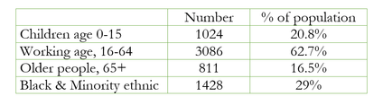
Datchet's Population
In 2015 the population of the village was 4921
Did you know…
Compared with the average for the Royal Borough of Windsor & Maidenhead, Datchet has:
Did you know…
Compared with the average for the Royal Borough of Windsor & Maidenhead, Datchet has:
- more children
- fewer retired people
- slightly more people of working age
- a higher proportion from Black and Minority Ethnic groups
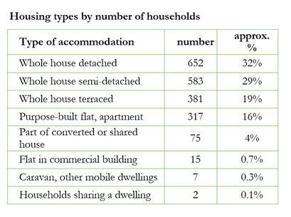
Housing in Datchet
In 2011, the total number of dwellings was 2127
Did you know…
The most common council tax band was C. There were 19 dwellings in the highest band (H) and 48 in the lowest band (A)
Also…
Did you know…
The most common council tax band was C. There were 19 dwellings in the highest band (H) and 48 in the lowest band (A)
Also…
- 3.4% of dwellings in Datchet have no central heating
- 4.5% of dwellings in Datchet do not have enough bedrooms for the number of people living there.
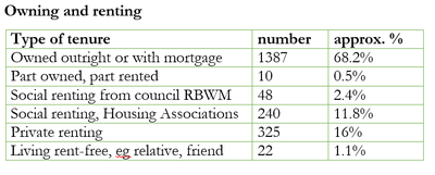
Are the majority of houses owned or rented?
More than 65% of dwellings (ie flats or houses) are owned outright or with a mortgage. 16% of dwellings are rented privately. Just over 14% are rented from RBWM or from a Housing Association.
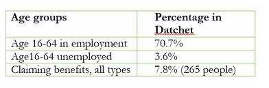
Employment in Datchet
How many of us are employed, unemployed or claiming benefits?
Figures in 2014 for the employed, the unemployed and those claiming benefits are all higher in Datchet than the average for Windsor & Maidenhead; percentages do not total 100 because not all people of working age identify themselves as employed or unemployed.
Figures in 2014 for the employed, the unemployed and those claiming benefits are all higher in Datchet than the average for Windsor & Maidenhead; percentages do not total 100 because not all people of working age identify themselves as employed or unemployed.
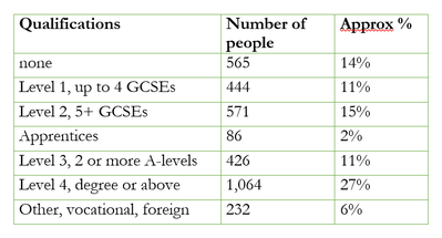
How well qualified are people in Datchet?
According to 2011 census statistics, of the 3928 people in Datchet aged 16 or over, 27% were educated to degree level or above; 14% had no qualifications.
According to 2011 census statistics, of the 3928 people in Datchet aged 16 or over, 27% were educated to degree level or above; 14% had no qualifications.
Risk of child poverty
How many children in Datchet are at risk of poverty?
In 2014, 16.2% of children in Datchet were at risk of poverty compared with the average figure of 9% across the Royal Borough of Windsor & Maidenhead.
Did you know that Datchet is ranked as high risk?
The Borough monitors the risk of child poverty through the 23 wards, the least deprived being listed as 23. In 2014, Datchet Ward was ranked as high risk, at number 3.
How is poverty measured?
Risk of Poverty figures measure the percentage of children in households which receive Child Tax Credits and have incomes 60% or less of the national median figure, plus some other indicators. The provisional estimate of median household disposable income for 2015/16 is £26,400; 60% of this is £15,840.
Datchet demographics
For more information about Datchet, produced by RBWM Council, please click here